Pipeline Awareness & Safety
Pipeline Awareness & Safety
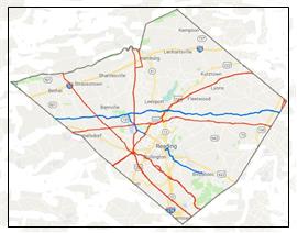
A number of pipelines carrying flammable and combustible liquids and gases traverse Berks County. These pipelines can transport a number of different materials at any given time. In most situations, multiple products could be moved through the pipe at the same time. For instance, a batch of unleaded gasoline may be immediately followed by diesel fuel which may be followed by a batch of home heating oil. Determining what product is located in a pipeline is managed by a control center which provides 24/7/365 monitoring of the flows, pressure, products, valves, pumps, compressors, and other components making up the pipeline. The information found on this page provides basic information on the pipelines and their operating companies throughout Berks County.
Pipelines Near You
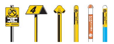
Operators of pipelines place markers on or near the pipeline route to identify the general location of the pipeline and to identify the product that is normally transported in the line. These markers do not indicate the exact location of the line and should not be used where preparing to excavate around the area.
Another way to identify the approximate locations of a pipeline is to use tools such as the National Pipeline Mapping System (NPMS). These online maps help you locate pipelines in or near your community. Maps generated by NPMS show the approximate location of gas and hazardous liquids transmission pipelines in relation to specific address, major roads, zip codes, cities and counties. Additional information on the National Pipeline Mapping System can be found by clicking the logo on the right.
Pipeline Operators
Each year, pipeline operators distribute public awareness information on the pipelines that are in the vicinity of homeowner's property. The information found below represents the current public information brochures of the pipelines located throughout Berks County.